Records
Records for each accession in the collection are housed in BG-BASE, a PC-based database.
Intensively curated, BG-BASE stores plant information including:
- Source of origin
- Specific provenance
- Date of acquisition
- Accepted botanical name and its synonyms
- Size upon receipt as well as at intervals throughout its history
- Number of specimens
- Map location on the grounds
- Presence of any vouchers in the cultivated herbarium or photographic images
Data may include performance observations, unique ornamental characteristics, growth and survival rates, hardiness potential, specific propagation techniques, a botanical description, and taxonomic verifications. Additional notations may document storm damage, susceptibility to insects or diseases, or experimental data. Observations on plant collections are ongoing and formal assessment activities are documented in the Arboretum’s Plant Inventory Operations Manual.
Identification, Taxonomy, and Nomenclature
The living collections of the Arnold Arboretum are curated to ensure that plants are correctly identified, that contemporary taxonomic or classification schemes are being considered, and lastly, that accurate nomenclature is being applied. A number of activities assist curatorial staff in accomplishing these goals: voucher herbarium specimens are prepared and deposited in the Herbarium of Cultivated Plants, the identity and correct name of accessions are researched, and the scientific literature is regularly reviewed. Also, because the collections are a resource for scientists around the world, much ‘taxonomic progress’ (i.e., changes in identification, taxonomy and/or names) occurs as a result of their research.
Labels
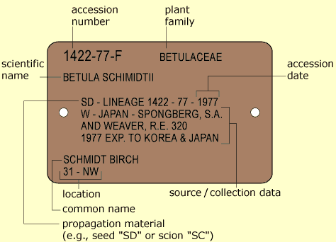
Plants in the collections retain anodized aluminum records labels that provide accession number, letter qualifier (denoting individuals of an accession), family, botanical name, means of propagation, lineage number, provenance (source/collection data), common name, and Arboretum grounds location. Each records label is embossed in-house using a CIM (card imaging master) Maxima 841 machine.
In addition to records labels, two types of display labels aid in interpreting Arboretum collections. The first and most ubiquitous are trunk labels that provide common and scientific names, nativity, and the botanical family to which the genus belongs. New trunk labels bear the afore mentioned information along with an accession number and year of accession. The second are stake labels which are positioned in front of plants in Azalea Border, Bradley Rosaceous Collection, Explorers Garden, Leventritt Shrub and Vine Garden, and Hunnewell Building areas. Stake labels provide nativity, common, and scientific names.
A thorough disscusion of labeling, including label standards and source guides, can be found in our Plant Inventory Operations Manual, Appendix I.
Mapping
The Arboretum utilizes a suite of ESRI Desktop and Mobile GIS software applications to manage, analyze, query, capture, manipulate, and display geographic information. Decimeter accurate field mapping of landscape features (e.g., plants, benches, signage) is accomplished using a Trimble TDC6 data collector and R580 GNSS antenna.
Locations within the Arboretum are defined by a grid overlaid onto a base map that divides the property into 77 individual maps, each 400 feet by 600 feet. Each map is further divided into 4 quadrants (200 feet by 300 feet) labeled NW, NE, SW, SE. Plant beds within named garden areas (e.g., Explorers Garden, Bradley Rosaceous Collection, Leventritt Shrub and Vine Garden) are given their own location designations. Taken together, these locations aid reserachers and visitors as they wayfind to plants within the collections. Plant locations are made available through our searchable plant inventory, published maps, and records labels.
Print or explore our collections using Arboretum Explorer.
Read more about GIS at the Arboretum or historic cartographic efforts in Arnoldia.
Contact Us
For more information on obtaining collection access, visit our Availability of Research and Propagation Materials page.